This is a very popular trail so I arrived early at sunrise and was able to cover almost all of the trail without seeing many people. It is rated an easy trail and I would agree. There are parts of the White Tail trail that will be hills and rocks but it is easily transversed.
Upon arriving, there is a flower bed, picnic tables, and an old jail to see. There are restrooms somewhere but I didn’t find them. I traveled the trail by going to the left or counter clockwise. Shortly into the hike, you will come to the waterfall. When I was there, it did have a little water flowing. You are able to walk up and around to the top and come down on the opposite side. It can be a little steep and rocky doing this. Along the trail, there are benches to sit and enjoy the scenery, animals, or peace and quiet. There aren’t many signs to help guide along the path but you should be able to figure out which way to go.
I did see some racoons and was able to get pretty close to a family of deer. A buck, doe, and two fawns. There is also the Blue Bird Trail that is another easy path to follow. It will intersect with the Old Kate Loop.
This was a First Day hike for me. All in all I did about 7 miles or so. I had walked this trail before but due to the rainy and muddy conditions in the area, I decided to do this one again because the trail is usually pretty dry. The trail was a little wet at the start but that is usually the case because of the runoff along the Tunnel Vision path. I enjoy this trail. There was no one on the golf course today, but I also started pretty early. Last time I was on this trail, there was construction after the golf course but today that was completed and I was able to go through the tunnel, “You got this”.
After I finished the trail on the All Trails app. I drove over to the beginning of the Tweety Bird trail and went to the left and through the tunnel which was decorated on both sides. After going for about a mile, I turned around and went back to the car as that was as far as I wanted to walk today. The Tunnel Vision trail seems to be rather long and I think I’m going to try and walk all of it some day and see how long it is.
It was a cloudy and cool day. By the time I was finishing, it was starting to get cold even though the temperature was higher than when I started.
The trails today were very easy for me. I enjoy going this time of year as you will sometimes see Christmas decorations along the trail.
This is a moderate rated trail. I actually found it very easy to walk. There were a few rocks and roots but very little elevation. You will be under tree cover for 99% of this trail. It is about an eight mile walk. Around the three mile mark, there is some kind of open area that appears to be where some type of games are played. About four miles in you can walk down to the water. This is the only area where swimming is allowed area at the lake. No boats are allowed. There is a bathroom at this point.
When you come to the cemetery, there is another trail Umber Ridge Trail that you can take but today I just continued on the Lakeview Trail.
A little way passed the cemetery, you will be able to go off trail for just a bit at the bridge and you can walk a little closer to the water. Here you will see boats on the water.
About the last mile or so, you will come out of the trees and cross the highway and then will be back in the trees for a bit and then travel on a service road and back to the parking area.
It isn’t the most exciting or pretty trail but it is a nice get-away if you want to have some alone time. I only encountered a park employee at the swimming area. Otherwise, I was alone on the trail. I did see a squirrel, several deer, and two wild turkeys.
All in all a very nice walk in the woods.
(After returning from my outing, I was told that it isn’t very safe to walk there by yourself. Several people had been attacked. I try to do my due diligence and stay safe but sometimes you never know until after the fact. Just be aware of your surroundings. I do usually have a walking stick and spray with me in hopes of being able to defend myself if needed.)
I did the yellow trail first which circles around the perimeter bottom. This trail was very pretty and had several scenic views. I did have to cross water several times and would definitely recommend waterproof boots or shoes. I had a couple of deer watching me from on top of the hill for a while. This was a pretty easy trail even though it was rocky in places.
After the yellow trail, I did the white trail which basically climbs the hill and is a moderate climb. This trail cut the yellow trail in half. When I reached the end of the white trail where it meets the yellow, I turned back and did it again.
All in all, a 6.5 mile hike.
I was the only one on the trail today and it was a cold wintery day and I would recommend this trail.
Today I participated in a guided hike to see the bison, or as most people call them buffalo, at Prairie State Park. The guide was very informative and the hike very short so when we reached the bison and the guide turned back to the visitor center, I and a few others continued on down the trail.
I did not get close to the bison as that can be very dangerous but I kept them in sight and continued on the path that went to the west and curved around and came up north of the visitor center. Eventually I came to a road which lead back to the parking lot.
This is mostly a grass trail and during the rainy season could be very wet and possibly be tick infested. I would rate the trails as easy.
Overall, it was a nice day to get outside and enjoy nature and see bison in the wild.
Because the bugs and ticks are still out and abundant this year, today I opted for a paved trail. In the All Trails app this is called the Fulbright Spring Greenway and rated an easy 7.9 mile trail.
At the trailhead, there is a descent sized parking lot and port-a-potties. There is also a little swing set and a bench so the kids can play and the adults can rest awhile. This trail does allow bicycles and everyone I met today on bikes were courteous and gave warning when they were approaching. A little way in, you will come to a fork in the road. I went right on the David C. Murray Trailhead (2.78). Most of this trail is shaded. There are a couple of creek crossings so if it has recently rained, you may have to cross water. There are also a few small inclines on the path I traveled today but nothing too strenuous. This trail does travel along side a shooting range so pay attention to the signs and do not follow the path into the range.
When you reach the Retiree Bridge, keep to the left and enter what used to be the Fulbright Landfill. You will eventually reach another trailhead and I followed the Ritter Springs Trailhead (1.85) until I reached the stop sign at Farm Road 88. There was quite a bit of traffic today so I didn’t want to walk on the road and I turned back at this point.
When I reached the intersection of the David C. Murray Trailhead and Truman Elementary Trailhead, I followed the Truman Elementary Trailhead until I reached the housing development. This was about a mile or so and then I turned around and went back to the parking lot.
The trail was fairly busy today with people walking dogs, people running, and others just out enjoying a walk. All in all, this was a very nice walk and should I need a paved trail in the future, I will come back and maybe start at the Ritter Springs Trailhead.
I visited Dogwood Canyon today. Due to all the rain in the area recently, a lot of the trails were closed or muddy so I opted for a paved trail and Dogwood Canyon did not disappoint. This trail is about 3 miles from the start to the end. There are a few dirt trails that lead off the paved path but I wasn’t able to travel on them during this trip.
All the falls in the park are manmade. You can rent bicycles instead of walking on the trail if you choose. Or there is a tram that will take you from the front to the back of the park and also through other parts of the park that are unavailable for walking or biking. All in all it was a nice trail. At the end of the paved trail where the turn around is, there is a waterfall with yellow trout in it. This is a very popular spot on the trail. This part of the trail is on the Arkansas side so you can say you walked from Missouri to Arkansas all in one day.
I was able to get about 7 miles in for the day.
At the entrance of the park, there is a museum that has interesting items on display. There are a couple of bathrooms along the trail. During the busy season, there are places to get food along the trail as well. There is an entrance fee to get into the park.
I hiked all of the trails at the Ruth and Paul Henning State Forest near Branson, Missouri to celebrate Trails Day and as a part of Earth Day week.
It was a very easy trail to visit the lookout tower, which I only made it part way up due to my fear of heights, and then I did the Red, Yellow, Blue, and Orange trails (basically covered every trail there.) Most of the time the trails were easy and then there would be that little bit that was more moderately challenging due to the rocks and tree roots, not to mention the elevation.
I saw several small waterfalls at various places. The trails were mostly clear other than a few spots that were wet due mostly to the water runoff from underground which made the trail a little muddy. I was able to see a few spring blooms but nothing real exciting stood out. The butterflies were probably the best part for me.
I have known about the Route 66 Mother Load Road all my life but have taken so many of the historical or interesting stops or granted. Today, I decided to travel from Tulsa to Vinita Oklahoma and check out some of the sights along this famous road. #route66
The first stop was the Center of the Universe which is just off the Route 66 path but because I was in the area, I decided to stop. The center is located in downtown Tulsa by the Tulsa Union Depot on Boston Ave. The Depot was closed but still a very interesting building. The artificial cloud is also here and is standing beside the center of the universe. When standing on the circle or the center of the universe, if you say something it will echo back to you. It was very interesting and I’m amazed that it could happen without any walls around you. If you have a minute and are in the area, stop in and experience it. #centeroftheuniverse
The next stop was Route 66 sign on southwest boulevard. At this location, there is history about what was once Crystal City which in the day was an amusement park and area for entertainment. From if you travel east, you will come to the Historic Red Fork District. I did stop and take a photograph of a mural but that was all today. I traveled on east to Tulsa’s Route 66 Historical Village. This is a very interesting stop but was closed during my visit but I was able to walk around and see the train, gas station, trolley car, and oil derrick. This oil derrick here is the tallest in America. #historicalvillage #crystalcity #oilderrick
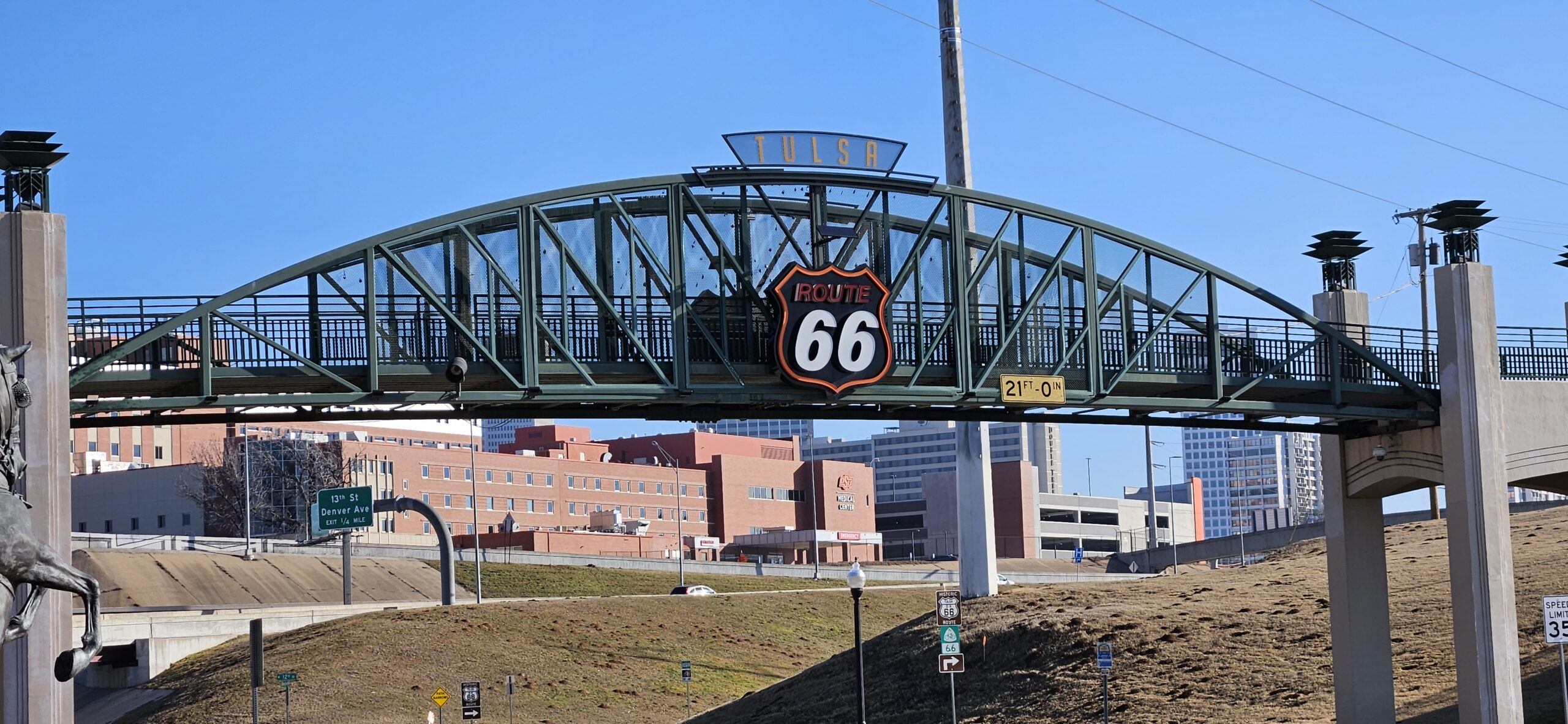
Traveling on eastward, I came to the Cyrus Avery Route 66 Memorial Bridge which is where east meets west on this route. Here the landscape beings to change and the road stretches out in anticipation of the journey to California. At this location there is a pedestrian and bicycle bridge that allows easy crossing of the highway. #cyrusavery
East of here I made a quick photo stop of the Meadow Gold sign, mural, and various statues. This is a very popular area. The next stop was the Ark of Catoosa and the Blue Whale of Catoosa. The ark is in disrepair but I’m sure at one time, it was fun to children to play in. The blue whale allows visitors to walk out on the water. #meadowgold #bluewhale
The H. Tom Kight Jr Bridge is the entrance to the Molly’s restaurant and today the restaurant was closed so I wasn’t able to go across it.
Next stop was the Totem Pole Park. This park is home to the largest concrete totem pole. There were several totem poles here and all sides of each pole was different and each pole represented something different. This too was closed today so I wasn’t able to visit the information center or gift shop but still worth the stop to see all the art work. #totempolepark
After the Totem Pole Park, I did stop and snap a photograph of the old gas station that was in town and then it was on to the Hi Way Café in Vinita for lunch. The food was great, as well as the service and atmosphere. Here you will find a car that has been stickered. Which means that the stickers were small, 66,000 of them, and they created the painting on the car. The car in inside the restaurant and well worth a stop to see. Outside the restaurant is another car the public is allowed to put stickers on if they choose. #hiwaycafe #vinitaoklahoma
There is still more to see along the route but this was a full day.
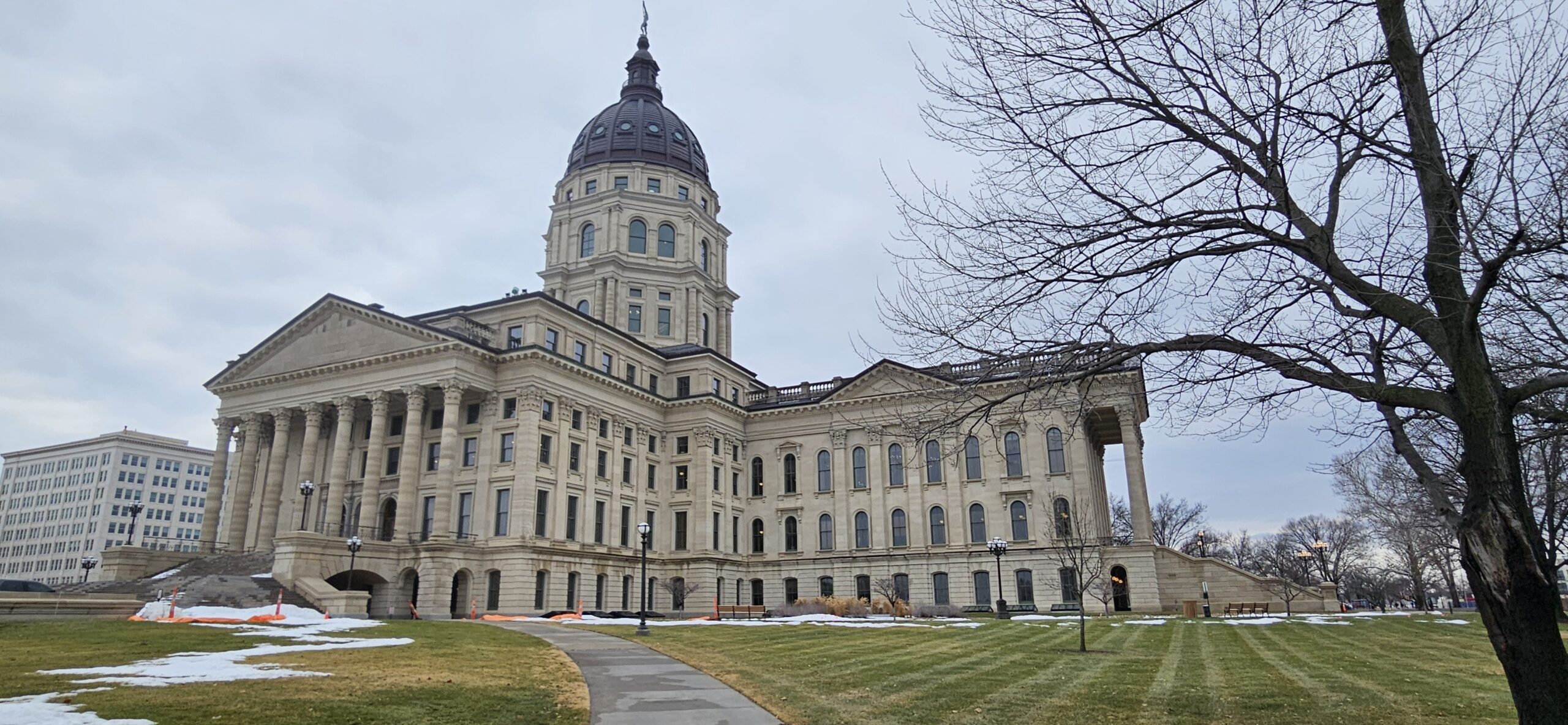
Today, I visited my Kansas State Representative, Dale Helwig at the Kansas State Capitol Building. Dale was able to give me a personalized tour of the capitol building. It is a very beautiful building. I have driven passed the capitol several times but never gone inside. There is so much Kansas history throughout the entire building. I did do the guided tour to the dome and the group leader mentioned that recent renovations had uncovered more paintings that no one seems to have record of. The paintings may be from the 1800’s. That area is still under construction so I’m not sure what paintings were discovered.
There are so many murals painted on the walls throughout the capitol and I’m sure I did not see them all. There are also many artifacts or replicas throughout and so much history.
I was able to visit the House of Representatives where Dale spends some of his time. The podium is called the “well”. There are beautiful murals on the ceilings and the room overall is very dramatic and beautiful.
I was able to visit the old Supreme Court Room which was very impressive as well. This room had photos of past Justices on the walls. This room is now used for other functions as the Supreme Court now convenes in a different building.
The library has recently been renovated and was very majestic as well. The floors in the library were originally made from glass as this helped light to come through as lighting was limited.
I was able to complete the entire dome tour. The tour guide said there were 296 steps. This tour begins on the 5th floor of the building. At each level, you are able to stop and circle the dome. The final level going to the top and to the outside is almost straight up and the very top is a spiral. I’m not one for heights so this was a great accomplishment for me and I’m so very glad that I completed it. I was hanging on for dear life while climbing the stairs and when walking around outside the dome I was hugging the dome but the view was incredible! This is a free tour and if you have time, I would highly recommend it. (If it is very hot outside, the tour will not run as near the top, there is no air conditioning and the heat can be unbearable.)
It seems like some type of construction is always happening at the capitol and today was no exception. But I was able to walk around most of the block and see the various statues and memorials. In the sidewalk, there are Kansas shaped blocks that have different people’s names in them. Much like the Hollywood Stars.
If you have a couple of hours to spend, you can do a self-guided tour or there are also guided tours. The architecture is so very beautiful and impressive. Today is a Friday and the capitol was busy but not overwhelming like Monday through Thursday can be. I had a very enjoyable day.